
Is there a way to display the runway extended centerline on any of the map or arc displays?
-
Just wondering. More modern avionic suites have this ability but it may not be native to the Starship. It would be really helpful in lining up with runways during visual approaches.
Thanks!
-
I haven't tried it myself but you can try to select an arrival runway and select visual approach (I forget exactly what it's called. Then you can use the course pre-select and set the course to the runway or whatever visual point is created.
@Sunake said in Is there a way to display the runway extended centerline on any of the map or arc displays?:
I haven't tried it myself but you can try to select an arrival runway and select visual approach (I forget exactly what it's called. Then you can use the course pre-select and set the course to the runway or whatever visual point is created.
There are a couple ways this is accomplished in later Proline 4 systems but the extended runway centerline display is I believe most representative of what is being described.
AFAIK the only way that would be possible is to construct an offset waypoint from a point that isnt the runway of the airport or a waypoint on the flight plan. For example take this flight plan, you are at JLI (right side) and going to KCRQ. But you want a 10 mile fix on the centerline. Well using the method described above, you need to identify where that point is referenced from some other point. in this case OCN R091 @ 17nm.
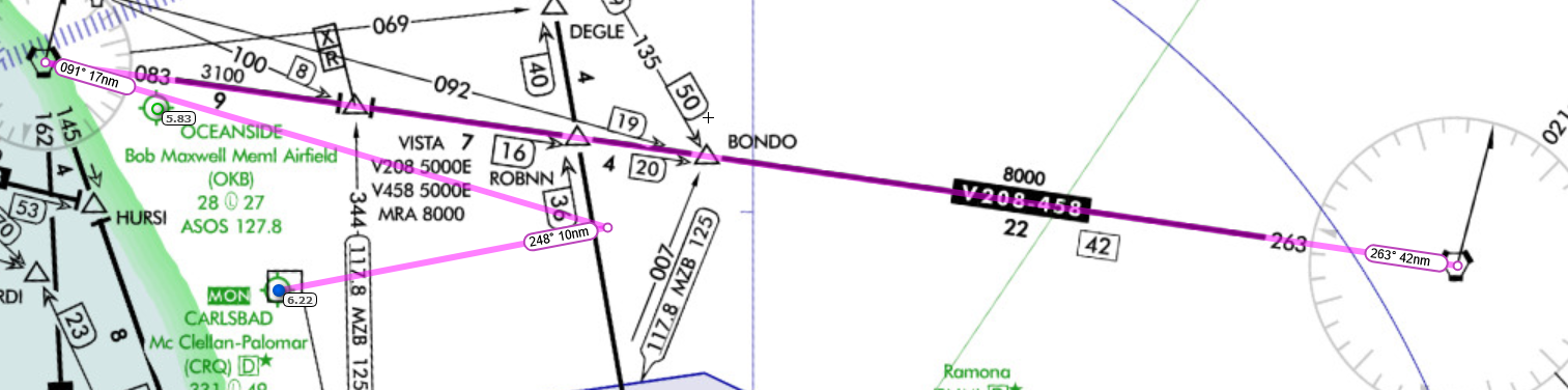
So your flight plan would be JLI, OCN (create offset 091 @ 17nm), KCRQ -
Thank you both for the info. Very helpful!
-
Ive tried using the course select option or whatever its called to just put a line through the airport waypoint in the direction of the runway, and it does help, but isnt accurate enough to actually guide you in IFR. Ive also tried doing an offset waypoint on the heading of the runway like 10 miles out, but it was similarly not very precise. Still helps with situational awareness, mostly when flying VMC. If an airport doesn't have an ILS or at minimum an RNAV approach and its IMC your options are limited (although if you use the GNS430 you get a few more options)
-
I was going to mention that there is a really good Android app called Avare that will display a moving map on your phone or tablet as you are running Flight Simulator. One can overlay VFR Sectionals, Low IFR-High IFR routes, etc., (at least for flights in the USA) and your aircraft in Flight Simulator will be shown at it's correct simulation coordinates on the moving map. When you build a flight plan with Avare, the app will automatically draw extended runway centerlines at both your departure airport and arrival airport. Avare is excellent for situational awareness and runway orientation.
The app pairs really well with the Starship's older avionics for situational awareness and I use it on every flight now.
Google Play Link here
Avare is completely free of charge and does not have any in-app adverts whatsoever (which makes it so cool).